
1
 Recent Posts
2
DB Cooper / Re: New Forum & News Updates
« Last post by georger on March 19, 2026, 10:44:36 PM »NEWS - yes a few people are still working the Cooper case. I cant say who or what but NEWS is under review and on the way. Just be patient. 
Hang in there.
Hang in there.
3
DB Cooper / Re: New Forum & News Updates
« Last post by georger on February 16, 2026, 03:07:09 PM »Good! Site back up and running .......... Gold Medal to Shutter! 
Thank you Chaucer for letting me know ....
Thank you Chaucer for letting me know ....
4
DB Cooper / Re: New Forum & News Updates
« Last post by Shutter on February 13, 2026, 07:23:44 PM »This is the second time them bastards got in...
5
DB Cooper / Re: New Forum & News Updates
« Last post by Parrotheadvol on February 13, 2026, 11:08:53 AM »Cool! The sites back up!
F'n hijackers. The irony!
F'n hijackers. The irony!
6
DB Cooper / Re: New Forum & News Updates
« Last post by Olemisscub on November 22, 2025, 03:27:53 PM »* Is there any way to establish the authenticity of these recordings?
Are you suggesting this is a hoax or from a movie or something? The audio tapes were barely audible when I got them. I was only able to restore the 12 minutes you are hearing after an entire laborious week working on their restoration. It would be nice to have something to confirm their provenance to know where they came from, but their authenticity seems self evident.
* How are the speakers identified? For example, how does one distinguish the Captain from the First Officer?
Having written a book on this case, surely you know Rataczak and Scott's voices...no? There is plenty of audio out there of them both talking about the case. Those are clearly their voices. Both have very distinct and unique voices.
* How would the crew be able to talk to Soderlind in real time, when the crew were at Sea-Tac and Soderlind was in Minneapolis (far out of radio range), and there were no cell-phones?
It is also well documented that Paul Soderlind was in communication with 305 throughout the event.
This from Tosaw, who spent a significant amount of time with Rataczak and Soderlind.
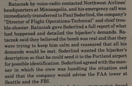
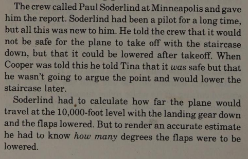
This from NWA themselves:
As for how it worked, Northwest Airlines maintained a company VHF radio station at SEA-TAC. To communicate with the crew, Soderlind spoke into a telephone landline that was patched into this Seattle NWA company radio transmitter. The Seattle ground station then broadcast his voice over VHF to the aircraft.
7
DB Cooper / Re: New Forum & News Updates
« Last post by Dfs346 on November 22, 2025, 05:21:14 AM »I am the one that got the audio and there is more that I am working on recovering.Many thanks for sharing these audio files. Some questions if I may:
* Are these audio files sourced (as reported on other forums) from the lady who now lives in Washington state and in 1971, worked for Northwest in Detroit?
* Is there any way to establish the authenticity of these recordings?
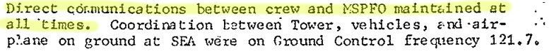
* Are the audio files arranged as follows:
00m00s to 04m33s: Sea-Tac ground control frequency (121.7 mhz)
04m33s to 07m12s: Northwest company frequency (131.9 mhz)
07m12s to 09m26s: Sea-Tac ground control frequency (121.7 mhz)
09m26s to 12m05s: Northwest company frequency (131.9 mhz)
* How are the speakers identified? For example, how does one distinguish the Captain from the First Officer?
* How would the crew be able to talk to Soderlind in real time, when the crew were at Sea-Tac and Soderlind was in Minneapolis (far out of radio range), and there were no cell-phones?
8
DB Cooper / Re: New Forum & News Updates
« Last post by nickyb233 on November 21, 2025, 10:57:49 PM »9
DB Cooper / Re: New Forum & News Updates
« Last post by Shutter on November 21, 2025, 07:23:59 PM »This is the kind of evidence needed...arguing over who said what or how someone walks gets you nowhere...
10
DB Cooper / Re: New Forum & News Updates
« Last post by nickyb233 on November 21, 2025, 02:21:49 AM »Did everyone see this?
Yes. I am the one that got the audio and there is more that I am working on recovering. It's probably the most important piece of outstanding evidence to date and I'm glad that I was able to bring it to the community. Ryan did an amazing job cleaning the audio up because what I got was rough.